


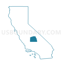
Voting District 10005, Tulare County, California
About
Outline

Summary
| Unique Area Identifier | 545555 |
| Name | Voting District 10005 |
| County | Tulare County |
| State | California |
| Area (square miles) | 2.34 |
| Land Area (square miles) | 2.34 |
| Water Area (square miles) | 0.00 |
| % of Land Area | 100.00 |
| % of Water Area | 0.00 |
| Latitude of the Internal Point | 36.05660700 |
| Longtitude of the Internal Point | -119.22627060 |
Maps


Graphs
Select a template below for downloading or customizing gragh for Voting District 10005, Tulare County, California


Neighbors
Neighoring Voting District (by Name) Neighboring Voting District on the Map
- Voting District 10050, Tulare County, CA
- Voting District 10075, Tulare County, CA
- Voting District 21715, Tulare County, CA
- Voting District 21960, Tulare County, CA
- Voting District 22045, Tulare County, CA
Top 10 Neighboring County Subdivision (by Population) Neighboring County Subdivision on the Map
Top 10 Neighboring Place (by Population) Neighboring Place on the Map
Top 10 Neighboring Elementary School District (by Population) Neighboring Elementary School District on the Map
- Pixley Union Elementary School District, CA (5,199)
- Tipton Elementary School District, CA (3,248)
- Woodville Elementary School District, CA (2,680)
- Pleasant View Elementary School District, CA (2,509)
Top 10 Neighboring Secondary School District (by Population) Neighboring Secondary School District on the Map
- Tulare Joint Union High School District, CA (78,539)
- Porterville Unified (9-12) School District, CA (47,072)